To receive Hickory Nut Gorge News once a month, please do Subscribe for free below by reviewing and then Subscribing at the end of the Newsletter.. All the news of the Lake Lure, Chimney Rock, and Hickory Nut
Gorge:
Subscribe to the Hickory Nut Gorge News, Inc
Copyright © 2006 Hickory Nut Gorge News ,Inc All Rights Reserved. Permission freely given to reprint by request to : Permission Request
Gorge:
Subscribe to the Hickory Nut Gorge News, Inc
Copyright © 2006 Hickory Nut Gorge News ,Inc All Rights Reserved. Permission freely given to reprint by request to : Permission Request
SHOW CASE YOUR BUSINESS ON OUR NEWSLETTER AND WEB SITE!
A TOP RANKED GOOGLE SITE!
CLICK HERE FOR INFORMATION ON HOW TO : ADVERTISE WITH US!!
A TOP RANKED GOOGLE SITE!
CLICK HERE FOR INFORMATION ON HOW TO : ADVERTISE WITH US!!


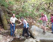
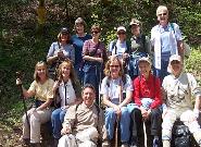
TAKE A HIKE IN OUR AREA!
To see who has and is working daily to preserve this sensitive and irreplaceable area do see PRESERVING THE GORGE PAGE.
Do join in this effort as everyone is needed!
Do join in this effort as everyone is needed!
RUMBLING BALD MOUNTAIN
BATCAVE
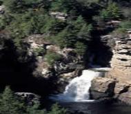
WORLD'S EDGE FALLS
AN IMPORTANT NOTE OF CAUTION!
- The Mountains of our area can, at times, be dangerous!
- Do not hike without an experienced " local" or an experienced guide.
- The Trails are unmarked and the Falls are never to be climbed
- Practice safe hiking at all times and leave no trace.!
- Do view this site provided by the Sierra Club on dangerous plants, animals etc.

CHIMNEY STATE ROCK PARK
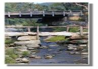
ROCKEY BROAD RIVER

FLORENCE PRESERVE

Easily accessed through Rumbling Bald Resort. Trail heads unmarked. Rapture Court is one access. Best to ask a resident on how to access.Rock
Miles of trails, all unmarked, Fox, deer bear abound
Check back later for updates on access info

World’s Edge contains a mile-long set of steep slopes on the eastern edge of the Blue Ridge Escarpment, with more than 20,000 feet
of streams and waterfalls.
From an overlook point, the land falls away to provide a stunning view of the Piedmont. The area provides habitat for rare flowers,
diverse forest communities, endangered bats and salamanders, unique cave-dwelling invertebrates, and birds such as peregrine
falcons and migratory neotropical species.
NC State Parks currently has not secured legal public access to the Worlds Edge and other state properties in Rutherford, Henderson
and Buncombe counties
Cave’s natural air conditioning: a cool moist draft that constantly pours out of vents on the side of the large cave. Bat Cave is the largest known granite fissure cave in North
America. The main chamber is a dark cathedral more than 300 feet long and approximately 85 feet high.
Fissure caves are formed by rock splits, boulder movements, and other motions of the earth, while most other caves are formed by water dissolving and abrading rock.
While seeing this impressive cave opening is the attraction for most visitors, the rugged slopes around Bat Cave contain an equally important array of habitats and creatures.
Bat Cave is owned by The Nature Conservancy and is accessible only through the North Carolina Chapter’s field trip program from June through early August
If you are a serious hiker with a true sensitivity to the land in all forms do contact The NC Nature Conservancy
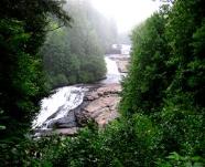
Chimney Rock Park is the natural fulfillment of your trip to the mountains. Take a deep breath of refreshing mountain air, become
invigorated by our hiking trails, and let your cares fade away in the cool mists of Hickory Nut Falls. This is the perfect place to reconnect
with nature and spend time with family and friends.
The Park, located 25 miles southeast of Asheville, North Carolina, offers the best of the mountains in one place-spectacular 75-mile views,
hiking trails for all ages, a 404-foot waterfall, a variety of special events and much more.
THE GREEN RIVER TRAILS
The Environmental and Conservation Organization of Henderson County (ECO) has a nice trail map and guide. Contact them at (828)
692-0385. Remember that the area is hunted, so check the hunting schedule before visiting.
See the Nature Conservancy Web Site
Stroll along the river!
Easy access from downtown Chimney Rock!
After walking " The River Walk" drive out of Chimney Rock for a miles or so and park along the Highway and explore the river on
your own.
Remember to leave NO TRACE of your walk!
Easy access from downtown Chimney Rock!
After walking " The River Walk" drive out of Chimney Rock for a miles or so and park along the Highway and explore the river on
your own.
Remember to leave NO TRACE of your walk!
Florence Nature Preserve is a 600-acre wooded tract in Hickory Nut Gorge owned by Carolina Mountain Land Conservancy.
Trails on the preserve provide moderately strenuous hikes on varied terrain. Visiting the preserve provides a chance to visit rock
outcrops, traverse a stream and enjoy the unique natural heritage. The Florence Nature Preserve is open to the public; visit www.
carolinamountain.org for a link to a map of the preserve. (Nita’s Country Store in Gerton also has a copy of the Florence map.) CMLC
also offers guided hikes on the preserve every year. Visit CMLC’s website or call 828-697-5777 for information on the next hike.
TRIPLE FALLS AND TRAILS AT DuPONT
Triple Falls flows on the Little River through the DuPont State Forest.
It is one of 4 major waterfalls on the Little River in this area, the others being High Falls, Hooker Falls, and Bridal Veil Falls.
Triple Falls has 3 distinct, different types of waterfalls View the short Video of Triple Falls
Visit the Web Site for all information
It is one of 4 major waterfalls on the Little River in this area, the others being High Falls, Hooker Falls, and Bridal Veil Falls.
Triple Falls has 3 distinct, different types of waterfalls View the short Video of Triple Falls
Visit the Web Site for all information
LINVILLE GORGE TRAILS AND WATERFALLS
Pure wilderness in the Gorge! Hiking, backpacking, and rock climbing are the major activities in the Gorge. The area, which includes 39 miles of
trails, is a rugged challenge to the most experienced hiker. Several rock formations along Jonas Ridge provide opportunities for the beginner,
intermediate, and advanced rock climber. Those seeking areas that offer a more solitary visit are encouraged to explore the southern portion of
the Gorge, south of the Conley Cove Trail in the western half, and south of the Chimneys in the eastern half.
Visit the Web Site for all information
Lake James State Park Hiking Trails

From I-40, take the Nebo/Lake James exit (exit 90) and head north. After a half mile, turn right onto Harmony Grove Road, and follow it for 2 miles to a stoplight.
Proceed straight across the intersection and past Nebo Elementary School to a stop sign. Turn right onto NC 126, and follow the signs to the park entrance 2.3
miles on the left.
All trails are well maintained and easy to follow. They start from the end of the parking lot opposite from the office.
Visit the Web Site
DONALD ROSS NATURE TRAIL-LAKE LURE
Now here is a new trail that is now available for your use and enjoyment!
- Located directly across from INGELS. It is a work in progress like all our trails. The trails are unmarked and relatively easy.
- We will be posting additional information and how you can help this great new addition to our town!

-40 to exit 73. After exiting, turn left, and go under Interstate. Immediately turn right. At fork, bear left onto Catawba River Road.
Road ends after 3 miles. Park on gravel shoulder on left. Trail begins across bridge and to right. Permission from land owner
required to proceed to trail from Catawba River Road. Some hikers will hike to falls from Ridgecrest Conference Center.
Catawba Falls is about 70 feet high
Road ends after 3 miles. Park on gravel shoulder on left. Trail begins across bridge and to right. Permission from land owner
required to proceed to trail from Catawba River Road. Some hikers will hike to falls from Ridgecrest Conference Center.
Catawba Falls is about 70 feet high
CATAWBA FALLS HIKE-BLACK MOUNTAIN-OLD FORT


LAKE LURE AND WESTERN NC HIKING TRAILS!